


SityTrail hiking trail GPS
Mô tả của SityTrail hiking trail GPS
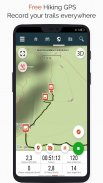
Đi và khám phá tất cả các con đường trên khắp thế giới
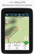
• Ghi lại những con đường mòn của bạn trong khi chụp ảnh HD và được gắn thẻ địa lý về những chuyến phiêu lưu của bạn.
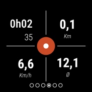
• Khoảng cách đã đi, km-nỗ lực, tốc độ trung bình, lượng calo đốt cháy, v.v.
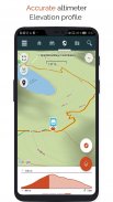
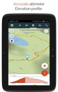
• Máy đo độ cao chính xác, tính toán chênh lệch độ cao và cấu hình độ cao hiển thị vị trí hiện tại của bạn.
• Báo động khi bạn đi chệch hướng của đường mòn đang theo dõi. Không cần phải quay lại!
• Tự động kích hoạt các điểm ưa thích với tính năng chuyển văn bản thành giọng nói.
• Tạo một tài khoản miễn phí và tất cả dữ liệu của bạn sẽ có sẵn ở mọi nơi trên mọi thiết bị.
• Dễ dàng tạo các đường đi và điểm ưa thích từ trang web của chúng tôi.
• Với trình chỉnh sửa trực tuyến của chúng tôi, hãy tạo các đường mòn của riêng bạn bằng trình duyệt Web trên PC / Mac và sau đó truy cập chúng trực tiếp từ điện thoại thông minh của bạn để trải nghiệm chúng trên mặt đất.
• Sắp xếp và phân loại các con đường và điểm ưa thích của bạn trong danh sách của riêng bạn.
Tiến xa hơn và trở thành người dùng PREMIUM!
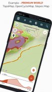
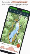
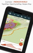
• Tải xuống bản đồ địa hình thế giới để sử dụng ngoại tuyến.
• Khám phá các con đường đi bộ đường dài GR, các tuyến đường đi bộ châu Âu, các tuyến đường Santiago de Compostela cho khách hành hương, v.v.
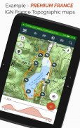
• Thêm bản đồ địa hình mà bạn lựa chọn, từ IGN Pháp, IGN / NGI Bỉ, IGN Tây Ban Nha, swisstopo, Áo, Hoa Kỳ (bản đồ địa hình USGS), Canada (Toporama).
• Bạn cũng có thể khám phá tất cả các mạng lưới đi xe đạp: Mạng lưới đường xanh ở Pháp, Ravel ở Bỉ, các tuyến đường đi xe đạp ở Châu Âu, mạng lưới điểm nút ở Flanders và Hà Lan.
• Và vào mùa đông, hãy khám phá tất cả các dốc trượt tuyết có tên của chúng.
• Truy cập danh mục công khai các đường mòn từ các thành viên và cộng đồng SityTrail.
• Các tính năng theo dõi và hướng dẫn nâng cao với tính toán khoảng cách và thời gian còn lại và hướng dẫn bằng giọng nói tại các giao lộ.
• Tiến xa hơn và biến những con đường mòn yêu thích của bạn thành những hướng dẫn đa phương tiện thực sự với văn bản, ảnh, liên kết video và chia sẻ chúng với cộng đồng SityTrail.
• Tạo cộng đồng đi bộ đường dài của riêng bạn và quản lý các thành viên và nguồn cấp tin tức của bạn.
• Tạo đường mòn với các tính năng nâng cao của chúng tôi để chỉnh sửa đường mòn qua trang web của chúng tôi.
• In đường mòn ở định dạng PDF với mã QR. (A4, A3).
• Truy cập các bài viết Wikipedia được gắn thẻ địa lý từ mô-đun SityTrip của chúng tôi.
Ghi lại đường đi trên đồng hồ Wear OS của bạn
Bạn có thể ghi lại đường đi trên đồng hồ Wear OS của mình ở chế độ độc lập (không kết nối với điện thoại thông minh Android) hoặc ở chế độ ghép nối (được kết nối với điện thoại thông minh Android).
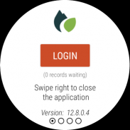
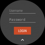
Ứng dụng cũng cho phép đăng nhập vào tài khoản SityTrail hiện có của bạn (từ màn hình ở bên trái nhiều nhất) khi đồng hồ được sử dụng ở chế độ độc lập.
Thông tin quan trọng
• Một số tính năng cần kết nối internet.
• Việc sử dụng GPS trong thời gian dài có thể làm giảm mức pin.
SityTrail hiking trail GPS - Phiên bản 12.15.8.3
(24-06-2025)SityTrail hiking trail GPS - Thông tin APK
Phiên bản APK: 12.15.8.3Gói: com.geolivesPhiên bản mới nhất của SityTrail hiking trail GPS
Phiên bản khác


Ứng dụng cùng danh mục


Bạn cũng có thể thích...


